
Current Location: 20.5N, 95.0W
Geographic Reference: 400 miles SSE of the Texas / Mexico Border
Movement: Northwest at 5 mph
Max Winds: 30 mph gusting to 35 mph
Current Hurricane Severity Index: 0 out of a possible 50 points (0 size, 0 intensity)
Max Predicted Hurricane Severity Index: 2 out of a possible 50 points (1 size, 1 intensity)
Current Radius of Tropical Storm-Force Winds: 0 miles
Max Predicted Radius of Tropical Storm-Force Winds: 50 miles
Organizational Trend: Steady
Forecast Confidence: Average
Chance of Development: 60 percent
Key Points
1. Regardless of development, the greatest threat to Mexico and southern Texas is flooding from heavy rainfall.
2. The forecast track has been shifted to the north
3. Significant impacts from wind and tidal surge are not expected.
Our Forecast
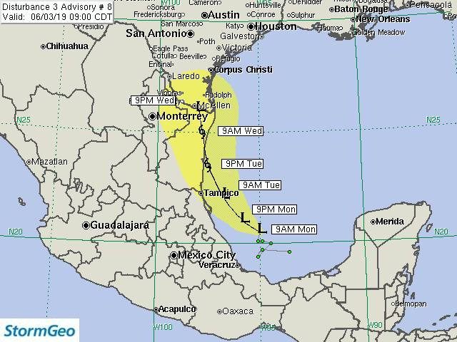
Disturbance 3 continues to meander in the southwest Gulf of Mexico. This slow motion is allowing for an upper trough over the western United States to move to the east, which should steer the system more to the north. The model guidance has shifted to the north as well. Our forecast follows these trends and now brings the system inland about midway between Tampico and the United States / Mexico Border.
Squalls have increased in association with Disturbance 3. However, early morning visible satellite imagery indicates that there is not a well-defined surface circulation. Environmental conditions are currently somewhat favorable for further development. Therefore, we continue to give the system a 60 percent chance of tropical development. The forecast is for the disturbance to become a minimal tropical storm before landfall. If the system were to move east of our forecast and move toward Texas, it would encounter strong wind shear, which would cause weakening or dissipation before landfall.
Since the system is not forecast to be any stronger than a minimal tropical storm, the greatest threat will be flooding from heavy rainfall. This threat will occur regardless as to whether or not the system develops into a depression or a tropical storm. Some of the rainfall will likely spread northward into Texas late Tuesday through early Friday.
Expected Impacts Onshore
Northeast Mexico – Tampico Area: Isolated power outages may occur due to strong winds. Widespread street flooding is expected. Some flood damage may occur, especially in areas that experience mudslides and near waterways.
South Texas: Some areas of street flooding will likely occur, which will result in travel delays.
Expected Impacts Offshore
Bay of Campeche to Offshore Tampico, MX: Scattered squalls will produce wind gusts up to 50 mph and locally rough seas.
Our next advisory will be issued by 3 PM CDT.
Meteorologist: Derek Ortt
![]()
| Forecast Confidence: Average | Hurricane Severity Index | ||||||||
|---|---|---|---|---|---|---|---|---|---|
| Fcst Hour | Valid | Lat. | Lon. | Max Sustained Winds | Max Gusts | Category | Size | Intensity | Total |
| 0 | 9AM CDT Mon Jun 03 | 20.50N | 95.00W | 30 mph | 35 mph | Tropical Disturbance | 0 | 0 | 0 |
| 12 | 9PM CDT Mon Jun 03 | 21.00N | 95.80W | 30 mph | 35 mph | Tropical Disturbance | 0 | 0 | 0 |
| 24 | 9AM CDT Tue Jun 04 | 22.00N | 96.70W | 35 mph | 50 mph | Tropical Depression | 0 | 1 | 1 |
| 36 | 9PM CDT Tue Jun 04 | 23.50N | 97.50W | 40 mph | 50 mph | Tropical Storm | 1 | 1 | 2 |
| 48 | 9AM CDT Wed Jun 05 | 25.00N | 97.80W | 40 mph | 50 mph | Tropical Storm | 1 | 1 | 2 |
| 60 | 9PM CDT Wed Jun 05 | 26.00N | 98.00W | 30 mph | 35 mph | Remnant Low | 0 | 0 | 0 |
The yellow cone represents track error from the previous five years. Over the past five tropical cyclone seasons, the center of the storm tracked within the yellow cone 75% of the time. The cone does not represent the forecast uncertainty in the current advisory for this storm. In addition, strong winds, very high tides, large waves, and heavy rainfall can often extend well outside the yellow cone.