
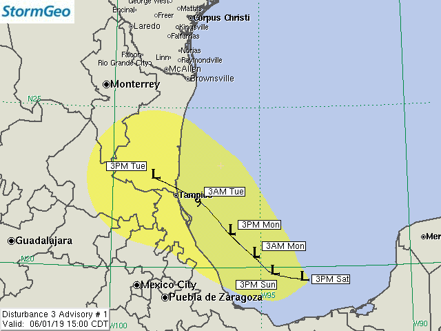
Current Location: 19.6N, 93.6W
Geographic Reference: 320 miles SE of Tampico, MX
Movement: West-northwest at 3 mph
Max Winds: 30 mph gusting to 40 mph
Current Hurricane Severity Index: 0 out of a possible 50 points (0 size, 0 intensity)
Max Predicted Hurricane Severity Index: 2 out of a possible 50 points (1 size, 1 intensity)
Current Radius of Tropical Storm-Force Winds: 0 miles
Max Predicted Radius of Tropical Storm-Force Winds: 60 miles
Organizational Trend: Slowly Becoming Better-Organized
Forecast Confidence: Average
Key Points
1. Disturbance 3 will likely become at least a depression prior to moving inland near Tampico, MX Tuesday morning.
2. The threat to the NW Gulf and Texas coast is low due to strong wind shear across the region.
Our Forecast
Satellite imagery and a recent wind satellite pass indicate that Disturbance 3 is slowly developing a low-level circulation center. Currently, squalls are quite limited in coverage and only extend out to about 120 miles north of the center of the disturbance. We estimate that there is a 60 percent chance that the disturbance will become a tropical depression or a weak tropical storm prior to moving ashore near Tampico, Mexico on Tuesday morning.
Atmospheric conditions in the path of the disturbance will not be extremely favorable for development. The disturbance will likely be encountering at least moderate wind shear up until landfall. North of Tampico, Mexico, the wind shear offshore northeast Mexico and the Texas coast is predicted to remain quite high through landfall. Should the disturbance track north of our forecast, then wind shear would likely lead to weakening or dissipation prior to landfall.
Regardless of whether or not this disturbance is classified as a depression or a weak tropical storm by landfall on Tuesday morning, the greatest threat will be from gusty winds in squalls offshore and for heavy rain inland across Mexico on Tuesday. Beyond Tuesday, remnant moisture may track northward into south and central Texas, resulting in areas of heavy rainfall.
Expected Impacts Onshore
Northeast Mexico – Tampico Area: Possible heavy rain Monday night and Tuesday, along with wind gusts to 45 mph. This could result in isolated power outages.
Expected Impacts Offshore
Bay of Campeche to Offshore Tampico, MX: Scattered squalls with locally rough seas and wind gusts to 45 mph.
Our next advisory will be issued by 9PM CDT.
Meteorologist: Chris Hebert
![]()
| Forecast Confidence: Average | Hurricane Severity Index | ||||||||
|---|---|---|---|---|---|---|---|---|---|
| Fcst Hour | Valid | Lat. | Lon. | Max Sustained Winds | Max Gusts | Category | Size | Intensity | Total |
| 0 | 3PM CDT Sat Jun 01 | 19.60N | 93.60W | 30 mph | 40 mph | Tropical Disturbance | 0 | 0 | 0 |
| 24 | 3PM CDT Sun Jun 02 | 19.80N | 94.60W | 35 mph | 45 mph | Tropical Disturbance | 0 | 1 | 1 |
| 36 | 3AM CDT Mon Jun 03 | 20.30N | 95.20W | 35 mph | 45 mph | Tropical Depression | 0 | 1 | 1 |
| 48 | 3PM CDT Mon Jun 03 | 21.00N | 96.00W | 35 mph | 45 mph | Tropical Depression | 0 | 1 | 1 |
| 60 | 3AM CDT Tue Jun 04 | 22.10N | 97.10W | 40 mph | 50 mph | Tropical Storm | 1 | 1 | 2 |
| 72 | 3PM CDT Tue Jun 04 | 22.80N | 98.60W | 30 mph | 35 mph | Remnant Low | 0 | 0 | 0 |
The yellow cone represents track error from the previous five years. Over the past five tropical cyclone seasons, the center of the storm tracked within the yellow cone 75% of the time. The cone does not represent the forecast uncertainty in the current advisory for this storm. In addition, strong winds, very high tides, large waves, and heavy rainfall can often extend well outside the yellow cone.

